Marshes, lagoons, swamps and peat bogs are humid zones, i.e. zones where water is the principal factor which controls the natural environment as well as the associated animal and vegetable life. Even though they occupy less than 5% of the land surface of the globe, these areas play a major role in human activity, in biodiversity, in the climate and in the water cycle. In effect, they produce one third of the atmospheric methane, one of the main greenhouse gases. Furthermore, these regions affect the transport of fresh water to the sea, and modify local meteorology by amplifying evaporation.
It is vital to better understand the behaviour and variability of these humid zones in order to be able to evaluate climate change and to recommend better ways to manage water resources. However, it has so far been something of a challenge to characterize their seasonal and inter-annual variations over the whole Earth, since these areas are so varied and are dispersed over the whole planet, ranging from the tropics to the arctic.
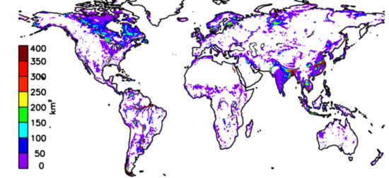
Combining and analysing simultaneously a very large number of observations from various satellites, scientists have managed to create the first map of the humid zones and their temporal dynamics, on the scale of the planet, for a fifteen year time period. The first conclusion : the extent of the water rich zones undergoes an important variation not only during the year, but also from year to year, with a strong modulation during the El Niño periods. Furthermore, the scientists have shown that between 1993 and 2007, the extent of the humid zones decreased by 6 %. This decrease was most marked in the tropical and subtropical areas. The most important decreases occurred in those regions where population has increased most markedly in the last two decades.
This study suggests therefore demographic pressure on the scale of the planet affects the hydrological cycles : this pressure acts notably through the drying up of marshes to make way for urbanisation, and by an increase in water usage in the humid areas.
Bibliography
Changes in land surface water dynamics since the 1990s and relation to population pressure, Prigent, C., F. Papa, F. Aires, C. Jiménez, W. B. Rossow, and E. Matthews, Geophysical Research Letters, doi:10.1029/2012GL051276, in press (2012).